About Nainital
 Nainital is located at a height of 1938 metres in the Central Himalayas in the Kumaon region. Kumaon is a glittering jewel in the Himalayan necklace, blessed with scenic natural splendour and varied natural resources. In the year 1841, Mr. P. Barron of Shahjahanpur was so moved by the scenic splendour of the place that he had a house constructed by the name "Pilgrim Cottage" and gradually a township sprung up around the lake. Nainital is a famous hill station and has a varied topography. There are various lakes in Nainital and as such it is also known as the Lake District of India. The main lake in Nainital is the Naini Lake and Nainital derives its name from this lake. This lake is ringed by hills and named after the goddess Naini. Nainital used to be the summer capital of the United Provinces during the British period and continued to remain so for many years even after independence. Its snow-capped peaks, verdant valleys, rolling meadows and crystal lakes have beckoned lovers of nature since ages. Nature has been generous in endowing Nainital with natural beauty and abundance of flora and fauna. Nainital was Jim Corbett's home for many years. Some of the important places and tourist attractions in the Nainital are Haldwani, Kaladhungi, Ramnagar, Bhowali, Ramgarh, Mukteshwar, Bhimtal, Sattal and Naukuchiatal. During winters, the hilly areas receives snowfall, while in summers, the plains experiences the temperature of 45 degree Celsius. Nainital can be visited throughout the year. The best time to visit Nainital is from April to May and October to November. Various tourists visit Nainital to explore its historical sites, wildlife reserve, fruit orchards, sanctified spots and the panoramic environment. Hindi, English and Kumaoni are the main languages which are spoken here.
TOURIST ATTRACTION:
The main tourist attraction in Nainital is the Naini Lake. The other tourist attractions in Nainital are the Naina Peak, Snow View, High Altitude Zoo, Khurpatal, Kilbury, Hanuman Garh, Land's End and State Observatory.
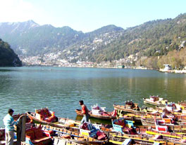
Naini Lake:According to the Hindu mythology, the deep green Naini lake is one of the emerald green eyes of Parvati, Shiva's wife. It is said that the modern Naina Devi Temple at the northern end of the lake is the exact spot where her eye is said to have fallen, after Vishnu chopped up her body and scattered it all over the countryside to stop Shiva's cosmic dance of destruction. The kidney shaped naini lake with its clear water is the center of the town. The rowing and paddle boats for boating enthusiasts are available at the Naini lake.
Khurpatal: Khurpatal is situated about 10 kms. from Nainital on Nainital - Ramnagar road. The Khurpatal lake is a heaven for anglers, and is inhabited by a number of fishes.
Naina Peak: Naina Peak is the highest peak and the most popular picnic spot in Nainital. This peak is situated at a height of 2610 meters, about 5.5 kms. from Nainital. This peak offers a captivating view of the snow-clad Himalayan ranges and the bird's eye view of Nainital on a clear day. It is also one of the most beautiful treks with soft cool air, shades of tall trees, songs of birds and the quaint summerhouse. One can either trek or go on horse back.
Kilbury: Kilbury is situated at a height of 2528 meters and about 11 kms from the town. It an ideal place for bird watchers, nature lovers, quiet weekend holiday and picnic. Kilbury is part of a forest reserve and is rich in flora and bird life.
Hanuman Garh: Hanuman Garh is situated at a height of 1951 meters above and 3.22 kms. from Nainital. It is a place of religious interest, and also famous for spectacular view of the sunset.
Snow View: Snow View is a scenic spot and offers a panoramic view of the Himalayan ranges. The Snow View Peak, at a height of 2270 meters is a popular vantage point in Nainital, accessible by a ropeway, horse and on foot. Its like a thrill for kids and adults for the ropeway ride from Aerial Express to Snow View.
High Altitude Zoo: The High Altitude Zoo is perched at an altitude of 2075 meters and about 1.5 kms. away from the Bus Station. The zoo houses a variety of species of animals living at higher altitudes and birds. Some of the endangered species of animals are the Siberian tiger, serow, leopard and Himalayan black deer. It is very important for researchers and scientists.
Land's End: The Land's End is situated at a height of about 2218 meters and 4.08 kms. trek from Nainital. The name Land's End suggests and one also feels that the end of the land has really come. This hill offers a panoramic view of Khurpatal, terraced fields, neighboring hills and valley. It is accessible by horse also.
State Observatory: State Observatory is situated at a height of 1951 meters, and 4.4 kms. from Nainital. The State Observatory undertakes astronomical studies and optical tracking of artificial earth satellites.
EXCURSION:
Bhimtal: Bhimtal is situated about 22 kms. from Nainital and blessed with a pristine aura. Bhimtal is one of the largest lakes in Kumaon and gets its name from the mighty Bhima, one of the five Pandava brothers in Mahabharata. Bhimtal has emerged as a favourite tourist destination and facilities like boating, fishing, sailing, rowing, exploring the surrounding forests and apricot and peach orchards are available for the tourists. A restaurant at the centre of the lake offers panoramic views. There is the centre of the Kumaon Umang Mahila Samiti outlet on the Ranibagh Road for woollens and fantastic homemade pickle. There is also the privately owned Folk Culture Museum at Mehragaon on the Bhowali Road. This museum was curated by Dr. Yashodhar Matpal and has an interesting collection of rock art.
Naukuchiatal: The Naukuchiatal is the nine-cornered lake and the deepest lake in the area. Naukuchiatal is a quiet hideway filled with birdsong and peace. This misty blue lake is cradled by green mountains and fed by an underwater spring, which keeps its waters high. This lake has religious significance and situated about 4 kms. from Bhimtal and 26 kms. from Nainital. This lake also harbours the biggest mahaseer fish. On the occasion of Ganga Dussehra, various people gather here. It is believed that one attains Nirvana if he manages to see all its nine corners. A huge statue of Hanuman, within the Mata Vaishno Devi Temple, is right at the entrance to Naukuchiatal.
Sattal: The Sattal is a group of seven small inter-connected lakes, set against a backdrop of oak and pine trees beyond which tower the Himalayas in Nainital. The Sattal is situated at a distance of 23 kms. from Nainital and 12 kms. from Bhimtal. The Sattal lake is the most picturesque lake in the Kumaon region hills. This place is ideal for a secluded holiday, peaceful mountain scenery and quiet walks into the hills and resorts. It is surrounded by a cover of thick forests. The holiday in Sattal can be combined with a grand taste of wildlife and adventure. Trekking through the forests and mountains, mountain biking, rock climbing, rappelling, river crossing, swimming, boating, kayaking and fishing are the various adventurous activities which can be undertaken here.
Bhowali: Bhowali is situated at a height of 1706 meters on the Ranikhet - Almora road. Bhowali is situated about 11 kms. from Nainital. Bhowali is a small town known for its Himalayan views and its scenic grandeur. Bhowali is also a beautiful health resort. The T.B. Sanatorium, named after King Edward is situated here. This sanatorium has treated luminaries like Subhash Chandra Bose and Kamala Nehru, wife of Pt. Jawaharlal Nehru. Bhowali is a major export centre for fruits like Apples, Apricot, Plums, Pears and Peaches etc. Only 3 km from Bhowali is Ghorakhal, famous for the temple of Lord Golla, the God of Justice and Sainik School. A beautiful mosque with a hilly architecture is located nearby. Bhowali can be visited round the year.
Jeolikot: The tiny hilltop village of Jeolikot was founded by Sri Aurobindo and Swami Vivekananda. Jeolikot is known as a health centre. It is also famous for its butterflies, honey mushrooms and fruits, including strawberries and leechies, it produces. The hills encasing Jeolikot are sprinkled with shrines and colonial structures. A tiny bunglow, once the home of a direct descendant of Napoleon Bonaparte and the house of Warwick Sahib, a retired major of the British army are some of the famous colonial buildings in the Jeolikot.
Ramgarh: Ramgarh is situated at an altitude of 1789 meters on Bhowali - Mukteshwar road. Ramgarh is situated about 25 kms. from Nainital and 14 kms. from Bhowali. Ramnagar is situated on the banks of the Kosi river and was set up by Commissioner H. Ramsay (1856 - 1884). Ramgarh would have been known as a culture capital rather than a hotbed of horticulture, if Rabindranath Tagore had stuck to his original plan of setting up a centre of learning here. He was not only spell bounded by the orchards, forest hillsides, babbling brooks and views of snow-clad Himalayas. But, he also eventually gifted Shantiniketan to his home state, West Bengal. The famous poets Rabindranath Tagore and Mahadevi Verma have praised the serenity of this place and composed their poems Geetanjali and Sandhya Geet here. Ramgarh is known for a variety of Himalayan fruits and the spectacular views of the Himalayan ranges. It is also a horticultural heaven, the fruit bowl of Kumaon. Ramgarh also houses a fruit-processing factory run by the Government. In Ramnagar, one can visit the archaeological ruins of Dhikuli, the Garjia Devi temple and Sitabani. The Garjia temple is built on a huge rock in the midst of Kosi river and named after the deity Garjia Devi. The ruins of Kotabagh are situated about 10 kms. from Rangarh, which date back to the Chand rulers. Ramgarh can be visited round the year.
Mukteshwar: Mukteshwar is situated at an altitude of 2286 meters on Bhowali-Devidhura road. Mukteshwar is situated about 50 kms. from Nainital and 25 kms. from Ramnagar. Mukteshwar is a small hill station covered with a thick wooded forest and offers a majestic view of the Himalayas. There is a very old Shiva temple at Mukteshwar. It is believed that the six ascetics have been engrossed in prayer for over a thousand years at the temple and are doing so even now. During Shivratri, the temple is the hub of much revelry. Near Mukteshwar is Chauli Ki Jali, a magnificent rocky cliff jutting out of the hillside. Leaning over the slanting rocks on the edge of this cliff, you can look all the way down to the base of the mountain. On a moonlit night, the place offers a spectacular view of the sparkling town of Almora and the majestic peaks of Adi Nampa of Nepal stretching upto the Chaukhamba Peaks of Garhwal. It is also famous for the hundred year old Indian Veterinary Research Institute campus. This institution not only has a beautiful icy-covered colonial building but also boasts of gorgeous and extensive grounds. On the IVRI's request, the Corbett visited the region. The institute has also taken on the responsibility of conserving and caring for the forests in the Mukteshwar range.
Kaladhungi: Kaladhungi is a romantic hamlet, situated about 35 kms. from the Corbett National Park and 34 kms. from Nainital via Khurpatal. Kaladhungi has been an inseparable part of the endless tiger stories of Kumaon that focused around the legendary hunter Jim Corbett. Kaladhungi was the residence of the Jim Corbett and he spent most of his life here. Today, the house of Jim Corbett is a comprehensive museum and houses souvenirs, relics and mementos related to Jim Corbett and his famous exploits. The Corbett Fall is situated close to Kaladhungi. The Corbett Fall is a beautiful waterfall with a drop of 20 mts. in the midst of sub-tropical forest. This forest is very well maintained and extremely rich in birds and plants life. Some other added attractions for the visitors are the "Nature Walk" museum and the adventurous camping sites.
Pangot: Pangot is situated about 15 kms. from Nainital. Pangot is an island of tranquility, where you can either lie soaking in the sun or do some vigorous walking in the dense oak forests. Pangot is a great place for bird watchers and trekkers. Pangot is excellent for long walks through the thick oak, pine, bamboo, cedar and rhododendron forests. The walk from the Kilbury Forest Rest House to Pangot is very popular.
HOW TO REACH:
By Air:The nearest airport is located at Pantnagar. Pantnagar airport is located about 71 km away and connected by air from Delhi.
By Rail: The nearest railway station is located at Kathgodam, about 35 kms. and connected to Lucknow, Agra, Delhi and Kolkata.
By Road: Nainital is well connected to Almora, Badrinath, Bareilly, Dehradun, Delhi, Haridwar, Kausani and the different parts of the country.
MAP OF NAINITAL: